Join 43,000+ fleet owners tracking smarter.

Start Freeor book a live demo
AVLView

GPS fleet tracking trusted by 43,000+ fleet owners worldwide. Automate operations, cut costs, and scale effortlessly.

GDPR Compliant
Singapore • 11 Countries Worldwide
Philippines•India
support@avlview.com
+65 8228 4559

Fleet tips, straight to your inbox

No spam, unsubscribe anytime.

support@avlview.com+65 8228 4559
Product
  • Fleet Tracking
  • Driver Safety
  • Fuel Monitoring
  • Maintenance
  • Geofencing
  • Landmarks & POIs
  • Reports & Alerts
  • Fleet Capacity
  • API Integration
Solutions
  • Partner Program50-75% margins
Resources
  • Blog
  • Help Center
  • API Reference
Company
  • About Us
  • Become a Partner
  • Contact
  • Pricing
Locations
  • Dubai
  • Riyadh
  • Singapore
  • India
  • Philippines
  • USA

© 2026 AVLView. All rights reserved.

Privacy PolicyTerms of ServiceEULACookie Policy

We use cookies to improve your experience and analyse site traffic. Cookie Policy

AVLView
Pricing
🇸🇬+65 8228 4559
العربيةLogin
Getting Started
Alerts & Reminders
Maps & Geofencing
  • Maps & Geofencing Overview
  • Track Your Fleet Live on the Map
  • Create a Geofence (Zone)
  • Create a Geofence from a Place Boundary
  • Watch Dashcam Video with a Trip
  • Watch a Zone: Quick Alerts from the Map
  • Create a Route Fence
  • Manage Your Saved Places
  • Set a Temporary Alert Zone (Quick Alert)
  • Share a Completed Trip
  • Create a Point of Interest (POI)
  • Replay & Export Trip History
  • Share a Vehicle's Live Location
  • Find Nearby Vehicles
  • Get Directions to a Vehicle or Place
  • Map Layers, Views & Traffic
Supported Devices
Reports
Analytics
Service & Maintenance
Trip Scheduling
Dashboard
Settings & Admin
Troubleshooting
What's New
Maps & Geofencing
Published Jul 2026

Track Your Fleet Live on the Map

On this page

  • How to track your fleet live
  • What the status dots mean
  • Organise the list
  • What the live track card shows
  • Frequently asked questions
  • Related

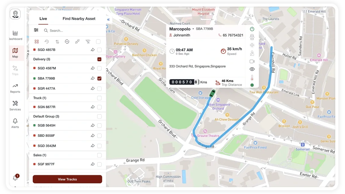
The Live tab in MapView shows where every vehicle is right now. You can filter by status, search for a specific vehicle, and open a live track card that follows a vehicle as it moves.
🖼️ IMAGE PLACEHOLDER — supplied by design

Dimensions: 1200 × 675 px (16:9) · PNG or WebP · under 200 KB

Shows: The MapView Live tab with the vehicle list, status filter row, and an open live track card over the map.

Alt text: MapView Live tab showing a fleet list with status dots and a live track card displaying speed, address, and sensor icons.

How to track your fleet live

  1. Open MapView and select the Live tab in the left sidebar. Your vehicles are listed in sections, each with a status dot, plate, and a “last updated Xm ago” time.
  2. Use the status filter row to narrow the list: All, Recently Tracked, Moving, Stopped, Disconnected, or Offline.
  3. Type in the search box to match by name, plate, or driver.
  4. Click a vehicle to focus it on the map. The floating live track card opens with its live details.
  5. Select multiple vehicles with the per-section or select-all checkboxes — the map fits its bounds to the selection.

What the status dots mean

  • Green — running (moving or ignition on).
  • Amber — idle.
  • Red — stopped.
  • Grey — offline.

Organise the list

  • Sort by — Name, Speed, Last Seen, or Distance.
  • Group by — Category, Driver, or None.
  • Filter by vehicle type — show only the vehicle types you need.

What the live track card shows

  • Identity — vehicle name and plate, plus driver name and phone.
  • Movement — last-seen time, live speed, or idle/stopped duration.
  • Location — current address and an animated odometer.
  • Sensors — fuel level, and status icons for ignition/power, door, A/C, seatbelt, and temperature.
  • Dashcam — if the vehicle has an MDVR dashcam online, a video icon opens the live camera stream.

The card is collapsible; dismiss it with the X or the Escape key.

Frequently asked questions

Why don’t I see fuel or temperature on the card?

Fuel and temperature icons only appear when the vehicle has the matching sensor installed. Without the sensor, those readings are hidden.

How do I focus the map on just a few vehicles?

Tick the checkboxes next to the vehicles you want — per section or with select-all — and the map automatically fits its bounds to your selection.

Related

  • Map Display Settings
  • View All Vehicles in an Area on the Map
  • Share a Vehicle’s Live Location
Next
Create a Geofence (Zone)
Draw a geofence (zone) in MapView using a polygon, rectangle, or circle, name it, then switch on Watch to get entry, exit, and dwell alerts.
Continue

Learn more about this feature

Explore feature

More in Maps & Geofencing

  • Maps & Geofencing Overview
  • Create a Geofence (Zone)
  • Create a Geofence from a Place Boundary
  • Watch Dashcam Video with a Trip
  • Watch a Zone: Quick Alerts from the Map
Didn't find what you needed?Contact support

In this guide

  • How to track your fleet live
  • What the status dots mean
  • Organise the list
  • What the live track card shows
  • Frequently asked questions
  • Related
Need a hand?

Talk to our team in your language.

Contact support