Join 43,000+ fleet owners tracking smarter.

Start Freeor book a live demo
AVLView

GPS fleet tracking trusted by 43,000+ fleet owners worldwide. Automate operations, cut costs, and scale effortlessly.

GDPR Compliant
Singapore • 11 Countries Worldwide
Philippines•India
support@avlview.com
+65 8228 4559

Fleet tips, straight to your inbox

No spam, unsubscribe anytime.

support@avlview.com+65 8228 4559
Product
  • Fleet Tracking
  • Driver Safety
  • Fuel Monitoring
  • Maintenance
  • Geofencing
  • Landmarks & POIs
  • Reports & Alerts
  • Fleet Capacity
  • API Integration
Solutions
  • Partner Program50-75% margins
Resources
  • Blog
  • Help Center
  • API Reference
Company
  • About Us
  • Become a Partner
  • Contact
  • Pricing
Locations
  • Dubai
  • Riyadh
  • Singapore
  • India
  • Philippines
  • USA

© 2026 AVLView. All rights reserved.

Privacy PolicyTerms of ServiceEULACookie Policy

We use cookies to improve your experience and analyse site traffic. Cookie Policy

AVLView
Pricing
🇸🇬+65 8228 4559
العربيةLogin
Getting Started
Alerts & Reminders
Maps & Geofencing
  • Maps & Geofencing Overview
  • Track Your Fleet Live on the Map
  • Create a Geofence (Zone)
  • Create a Geofence from a Place Boundary
  • Watch Dashcam Video with a Trip
  • Watch a Zone: Quick Alerts from the Map
  • Create a Route Fence
  • Manage Your Saved Places
  • Set a Temporary Alert Zone (Quick Alert)
  • Share a Completed Trip
  • Create a Point of Interest (POI)
  • Replay & Export Trip History
  • Share a Vehicle's Live Location
  • Find Nearby Vehicles
  • Get Directions to a Vehicle or Place
  • Map Layers, Views & Traffic
Supported Devices
Reports
Analytics
Service & Maintenance
Trip Scheduling
Dashboard
Settings & Admin
Troubleshooting
What's New
Maps & Geofencing
Published Jul 2026

Maps & Geofencing Overview

On this page

  • How to find your way around MapView
  • What the right toolbar does
  • What you can do here
  • Frequently asked questions
  • Related

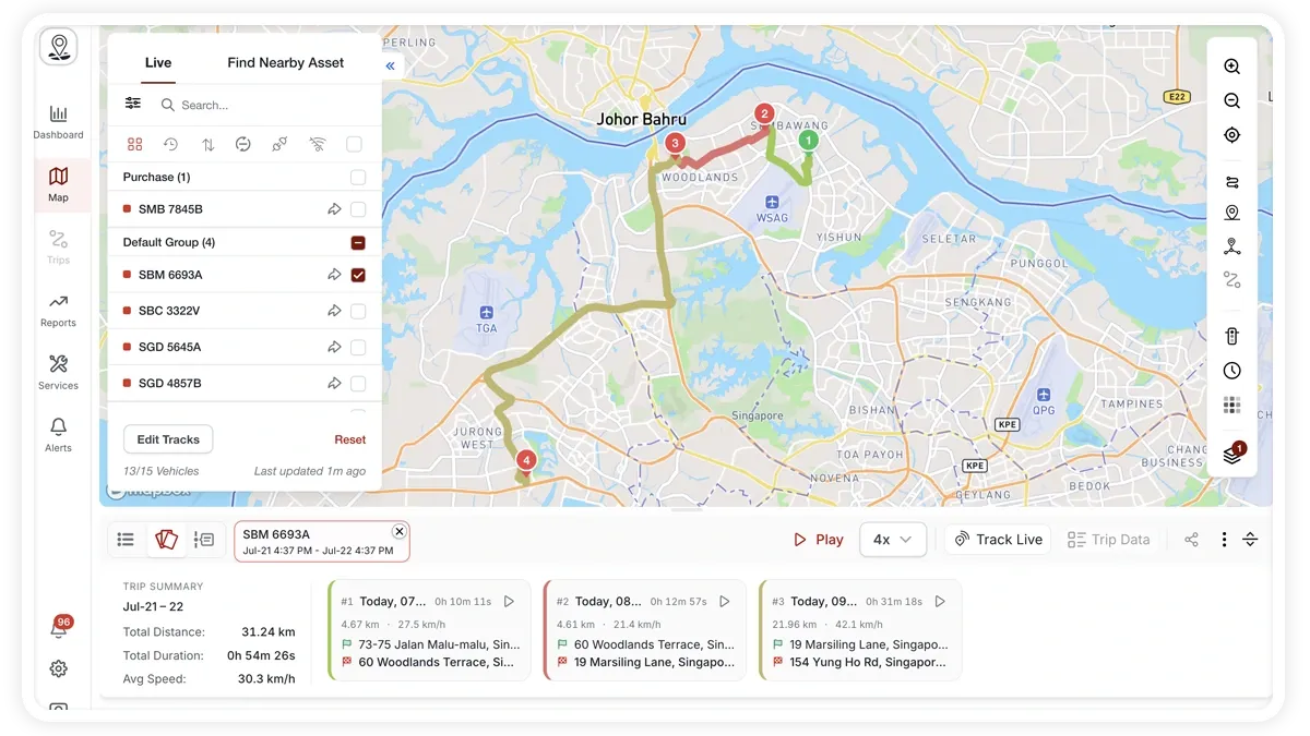
Maps & Geofencing — the MapView area — is your live fleet map. It brings vehicle tracking, trip history, geofences, points of interest, and alerts together on one screen so you can see where every vehicle is and act on it.
🖼️ IMAGE PLACEHOLDER — supplied by design

Dimensions: 1200 × 675 px (16:9) · PNG or WebP · under 200 KB

Shows: The MapView screen with the Live/Find Nearby sidebar on the left, the vertical map toolbar on the right, and the trip-history toolbar along the bottom.

Alt text: AVLView MapView live fleet map with sidebar, right toolbar, and bottom trip toolbar labelled.

How to find your way around MapView

  1. Left sidebar — a Live tab lists your vehicles, and a Find Nearby tab finds the closest vehicles to any point.
  2. Right toolbar — a vertical strip of map tools running down the side of the map (described below).
  3. Bottom toolbar — handles trip history and playback once you load tracks for a vehicle.

What the right toolbar does

  • Zoom — zoom the map in and out.
  • Current location — centre the map on where you are.
  • Layers — switch the base map layer and turn on heatmaps.
  • POI / geofencing tool — create points of interest, geofences, and route fences, and ‘watch’ a zone for alerts.
  • Get directions (‘Go to’) — route to a place or vehicle.
  • Quick Alert — drop a temporary alert zone on the map.

What you can do here

  • Track vehicles live and find the nearest vehicle to a point.
  • Switch map layers and heatmaps to change how the map looks.
  • Replay trip history with playback controls.
  • Create POIs, geofences, and route fences, and watch a zone for entry/exit alerts.
  • Get directions and drop a temporary alert zone.
  • Share a vehicle’s live location or a completed trip.

Frequently asked questions

Which map provider does MapView use?

MapView runs on Mapbox by default. If you prefer, you can switch to Google Maps in Settings.

Do I need extra hardware for the map?

No. Live tracking and geofencing work with any supported GPS device. Some extras — such as trip dashcam video or fuel figures — depend on additional hardware like an MDVR dashcam or a fuel sensor.

Related

  • Live-track vehicles on the map
  • Create a geofence
  • Create a POI or zone
Next
Track Your Fleet Live on the Map
Follow every vehicle in real time from the Live tab in MapView — status filters, search, sort, grouping, and a live track card with speed, address, and sensor readings.
Continue

Learn more about this feature

Explore feature

More in Maps & Geofencing

  • Track Your Fleet Live on the Map
  • Create a Geofence (Zone)
  • Create a Geofence from a Place Boundary
  • Watch Dashcam Video with a Trip
  • Watch a Zone: Quick Alerts from the Map
Didn't find what you needed?Contact support

In this guide

  • How to find your way around MapView
  • What the right toolbar does
  • What you can do here
  • Frequently asked questions
  • Related
Need a hand?

Talk to our team in your language.

Contact support