How GPS Vehicle Tracking Works: A Simple Guide for Fleet Owners

What You'll Learn
Follow a single location update from satellite to screen and understand exactly how GPS vehicle tracking works — no engineering degree needed.
Best for:
Logistics & Delivery professionals and fleet managers
GPS vehicle tracking works in four steps: a device in the vehicle listens to GPS satellites to work out its position, packages that position with data like speed and ignition status, transmits it over the mobile network to a cloud platform, and the platform turns it into a live map, trip history and alerts you can act on.
That's the whole system. Everything else — geofences, fuel graphs, driver scores — is built on top of that simple loop, repeating every few seconds for every vehicle in your fleet.
This guide walks through each step in plain language, then answers the practical questions fleet owners actually ask: how accurate is it, what happens in tunnels, and what does it cost to run.
First, the Term You'll Keep Seeing: AVL
Vehicle tracking is often called AVL — Automated Vehicle Location. Same thing: a system that determines where each vehicle is automatically and continuously, without anyone calling the driver to ask.
If you're comparing providers, you'll see "GPS tracking," "AVL," "fleet tracking," and "vehicle telematics" used almost interchangeably. The first three describe the location layer this guide covers. Telematics goes further — it adds the vehicle's own engine and fuel data on top. We've covered that difference in detail in GPS tracking vs telematics.
How GPS Vehicle Tracking Works, Step by Step
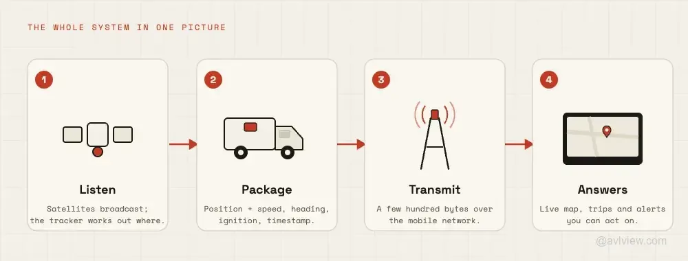
Let's follow one single location update — one "ping" — from orbit to your screen. Say it's 8:02 am and a delivery van is pulling out of a depot in Lagos.
Step 1: Satellites Broadcast, the Tracker Listens
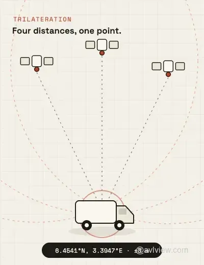
Around 30 GPS satellites orbit the Earth, each constantly broadcasting two things: who I am and what time it is — measured by an atomic clock.
The GPS tracker installed in the van does nothing but listen. By comparing how long each satellite's signal took to arrive, it calculates its distance from each one. With signals from four or more satellites, geometry does the rest: there's only one point on Earth that matches all those distances at once.
At 8:02:00, the tracker knows it sits at 6.4541°N, 3.3947°E — accurate to within a few metres. One important detail: the tracker only receives satellite signals. Nothing is sent to the satellites, which is why tracking works the same in Lagos, Dubai or Manila.
Step 2: The Tracker Packages the Position with Vehicle Data
A position alone isn't very useful, so the tracker bundles it with what else it knows at that moment: speed (32 km/h), heading (north-east), ignition (on), and the exact timestamp.
Depending on the hardware, that bundle can also include odometer reading, fuel level or sensor states — the richer inputs that power fuel monitoring and driver behaviour scoring on capable devices.
Step 3: The Bundle Travels Over the Mobile Network
The tracker has a SIM card, just like a phone. It sends the data bundle — a few hundred bytes, smaller than a WhatsApp message — over the cellular network to the tracking platform's servers.
This repeats every few seconds while the vehicle moves. Data usage is tiny: a vehicle tracked all month typically consumes only a few megabytes.
Step 4: The Platform Turns Data into Answers
The cloud platform receives the ping, checks it against everything it knows — assigned driver, planned route, geofences, speed limits — and updates the live map.
At 8:02:07, roughly seven seconds after the van moved, a fleet manager anywhere in the world sees it: moving, on schedule, driver logged in. No phone call needed.
What You Actually See: From Raw Data to a Living Map
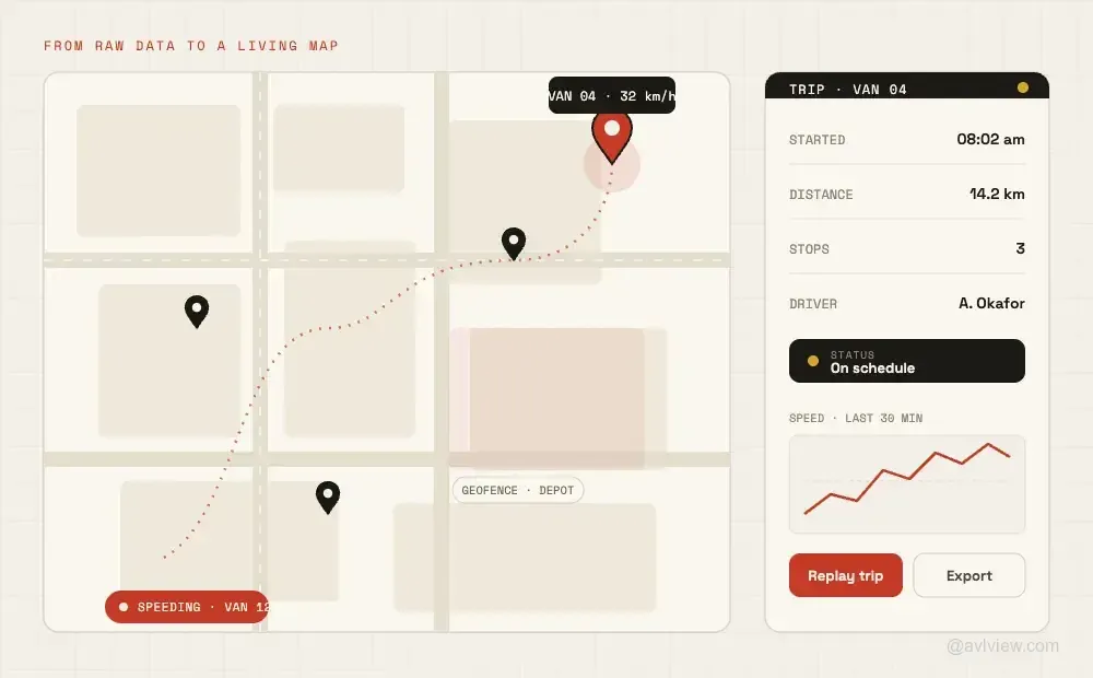
Multiply that single ping by every vehicle, every few seconds, all day — and the platform's real job becomes clear: turning millions of data points into a handful of simple answers.
- Live map — every vehicle's position, speed and status at a glance (live vehicle tracking)
- Trip history — every journey replayable: route taken, stops made, time at each customer
- Alerts — the platform watches so you don't have to: speeding, night driving, or a vehicle leaving an approved zone triggers an instant notification
- Geofences — virtual boundaries around depots, customer sites or entire cities that log every entry and exit (geofencing)
- Reports — daily and weekly summaries of distance, utilisation and stops, delivered automatically (fleet reports)
This is the difference between data and visibility. You don't watch the map all day — the system tells you when something needs you.
What Happens in Tunnels, Basements and Dead Zones?
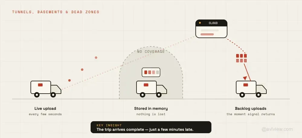
The two most common worries about GPS tracking have the same reassuring answer.
"What if there's no mobile coverage?" The tracker keeps working. It stores positions in its internal memory — thousands of them if needed — and uploads the entire backlog the moment coverage returns. The trip appears in your history complete, just a few minutes late.
"What if the signal is blocked?" Underground parking and tunnels do pause satellite reception briefly; tracking resumes within seconds of reaching open sky. But repeated, convenient signal losses on one vehicle usually aren't geography — drivers have their own methods, and each one leaves a detectable pattern. We've documented all of them in 9 ways drivers block or cheat GPS trackers.
What Fleet Owners Actually Do With It
Understanding the mechanism matters less than what it changes operationally. Across the 43,000+ fleet owners using AVLView, the first-year wins are remarkably consistent:
Fuel spend drops. Idling, detours and off-book trips become visible — and typically 8–15% of fuel cost comes back. Here's how GPS tracking cuts fuel costs in practice.
Deliveries speed up. Live positions plus trip data feed better routing — fleets running route optimization commonly cut delivery times by up to 30%.
Disputes end. "We waited an hour at your gate" becomes a timestamped fact, not an argument. Proof of arrival and departure is built into every trip.
Safety improves. Speed alerts and driving-behaviour data give you a fair, factual basis for coaching drivers — before the accident, not after.
Curious what this looks like on a real fleet? Watch a 5-minute demo →
What Does GPS Vehicle Tracking Cost?
Two components: the hardware (a one-time cost per vehicle, varying with capability — basic location vs full telematics) and a monthly subscription per vehicle for the SIM data and platform.
The trap to avoid is locked-in hardware — providers whose devices only work with their platform, so switching later means re-buying hardware for the whole fleet. AVLView is device-agnostic: it works with 200+ GPS tracker models, which means existing trackers can usually be connected as-is, and you're never hostage to one vendor's hardware pricing. See current plans for per-vehicle pricing.
The Bottom Line
GPS vehicle tracking is simple at heart: satellites give the position, the mobile network carries it, and the platform turns it into answers — where is everything, is it on plan, and what needs my attention.
The technology has been proven for two decades. The only real decisions left are which hardware fits each vehicle and which platform turns the data into action. That second one is where we'd like to show you what AVLView can do.
See your own vehicles on the map this week. Get a free demo →
Frequently Asked Questions
How accurate is GPS vehicle tracking?
Modern trackers are accurate to within 2.5–5 metres under open sky — precise enough to tell which side of the street a vehicle parked on. Accuracy dips briefly in dense high-rise areas or under heavy tree cover, and platforms smooth this out automatically using route-matching.
Does GPS tracking work without internet or mobile coverage?
The GPS position always works — satellite reception doesn't need the internet. Only the transmission needs mobile coverage, and when it's unavailable the tracker stores positions in memory and uploads them automatically once coverage returns. You never lose the trip; you just see it a few minutes later.
How often does a GPS tracker send updates?
Typically every 5–30 seconds while moving, configurable per fleet. More frequent updates give smoother live tracking; less frequent ones save data. Parked vehicles report far less often — usually a heartbeat every few minutes.
Will a GPS tracker drain my vehicle's battery?
No. A tracker draws about as much power as a phone charger while driving, and drops into a deep-sleep mode when parked. Hardwired units are installed with a low-voltage cutoff, so even a vehicle parked for weeks starts normally.
Do I need new GPS trackers to use AVLView?
Usually not. AVLView supports over 200 GPS tracker and telematics device models, so trackers you already have installed can typically be reconnected to the platform without buying new hardware — one of the advantages of a device-agnostic system.
Last updated: July 2026.
Ready to Transform Your Fleet Operations?
See how AVLView helps fleet managers like you cut costs, improve safety, and boost efficiency with real-time GPS tracking.
Related Articles
The Complete Guide to Driver Safety Scoring Systems
Learn how driver safety scoring systems work, how they reduce accidents by 40%, lower insurance premiums, and improve driving behaviour.
Driver Accountability: How Rankings Build Visibility and Healthy Competition
Rankings turn raw driving data into visible, comparable performance. See how safety scores, league tables, and trend tracking build accountability across your fleet.
Fleet Health Score: One Number Per Vehicle
A single 0-100 fleet health score per vehicle replaces guesswork with clarity. Know exactly which vehicles need attention and why.
Join 43,000+ Fleet Owners Who Trust AVLView
AVLView helps you:
- Cut fuel costs by 8-15% within 90 days
- Improve driver safety and reduce accidents by 40%
- Get real-time visibility into every vehicle 24/7
- Automate reporting and save 10+ hours per week
- 30-day pilot program with no long-term commitment